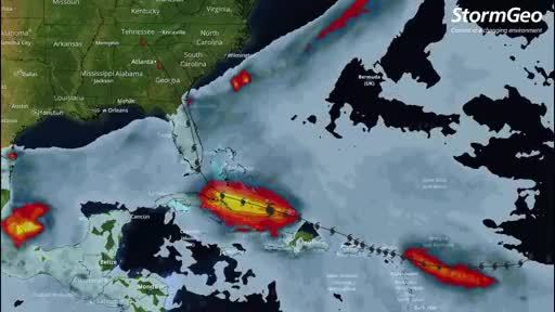
HOUSTON, Sept. 8, 2017 /PRNewswire/ -- Meteorologists at StormGeo's Houston weather center expect Hurricane Irma to make landfall over much of South Florida as a Category 4 or 5 Sunday morning. Wind gusts could reach 160 miles per hour (MPH).
According to StormGeo meteorologist Derek Ortt, "Our forecasts show that Tropical storm force winds are expected to make landfall in South Florida Sunday morning. Our forecast continues to keep the center over the Florida Peninsula, passing near Jacksonville Monday morning. Thereafter, Irma should turn back to the northwest as it moves into Georgia."
Ortt continues, "Irma has weakened a little. It is possible that the winds are a little lower than the 160 MPH we are currently estimating. Additional weakening is likely today as Irma completes a traditional eyewall replacement cycle. This weakening is accompanied by a broadening of the wind field. With environmental conditions being quite favorable for intensification, we expect Irma to re-intensify. It is quite possible that Irma will be a category 5 hurricane when it moves into Florida. Slower weakening than usual is expected as Irma moves up the Florida Peninsula due to its proximity to the water. Irma is forecast to remain a hurricane into Georgia."
StormGeo utilizes both U.S. National Hurricane Center and European models in its forecasts.
Note to reporters
Animated video track for press use here.
Hurricane Irma Interesting Facts here.
Daily updates by StormGeo meteorologists here.
About
StormGeo is a world leading weather forecasting service company with 23 global offices and operating several 24/7/365 weather centers for customers in Shipping, Oil & Gas, Energy, Media, Aviation and Cross Industries. For more information visit www.stormgeo.com.
SOURCE StormGeo


Share this article