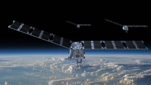
MOUNTAIN VIEW, Calif., May 6, 2024 /PRNewswire/ -- Muon Space, an end-to-end Space Systems Provider that designs, builds, and operates mission-tailored low-earth orbit (LEO) satellite constellations, in partnership with Earth Fire Alliance (EFA), is proud to announce the FireSat Constellation. This groundbreaking initiative aims to transform global wildfire response and enhance climate resilience worldwide. FireSat has been developed over the last five years with the expertise and support of Google Research and leading non-governmental organizations (NGOs) including the Environmental Defense Fund (EDF), Google.org, the Gordon and Betty Moore Foundation, and the Minderoo Foundation along with guidance from over 200 members of the federal, state, and local fire community. The FireSat Constellation will provide the most comprehensive, high-fidelity data to protect Earth's ecosystems from the escalating threat of wildfires. The Moore Foundation's report on wildfire details the billions of dollars of economic value that can be generated with even small improvements in response times.
The first phase of the FireSat Constellation, launching in 2026, will consist of three Muon Halo™ satellites equipped with state-of-the-art 6-band multispectral infrared (IR) instruments designed and optimized for the wildfire mission. Designed to capture comprehensive fire characterization data across every stage of a fire's lifecycle, the FireSat Constellation will give decision-makers and first responders near real-time insights, enabling informed responses and facilitating the adoption of beneficial fire management practices. With the first three satellites, the FireSat Constellation will observe every point on Earth at least twice a day, with key wildfire-prone regions revisited more frequently. At full capability with 50+ satellites, the revisit times for most of the globe improve to 20 minutes, with the most wildfire-prone regions benefitting from sampling intervals as short as nine minutes.
"We are excited to introduce this transformative capability to fire-response communities," said Brian Collins, Executive Director of Earth Fire Alliance. "We believe that high-fidelity data, equitably accessible on a global scale will help us more effectively reduce the negative impacts of wildfire, improve land management, and recognize beneficial fire practices that contribute to more resilient communities. FireSat will change the way we view wildfires across the planet."
Distinguished by its advanced multispectral IR instrument, the FireSat Constellation is uniquely equipped to differentiate genuine wildfire events from false positives and enhance the accuracy and reliability of wildfire detection and assessment of fire intensity. The FireSat constellation will operate in LEO with an observation swath of 1,500 km and an average ground sample distance of 80m. The instrument can detect sites of fire ignition and hot spots as small as 5x5 meters.
"Muon is proud to have worked with our NGO partners and over 200 members of the research and fire communities to design a solution to the growing wildfire threat we face in North America and around the world," said Dan McCleese, Chief Scientist of Muon Space. "In partnership with Earth Fire Alliance, we are seeking to empower not only first responders but also communities and policymakers with the insights needed to combat the escalating threat of wildfires, building a more resilient future for generations to come."
Chris Van Arsdale, who helped initiate the project from Google Research and sits on the Earth Fire Alliance Board of Directors, stated: "This dataset will be a valuable foundation for Earth Science research. Together with the fire community, we are looking forward to applying modern machine learning techniques to scalably detect and track fires globally to make it usable for on-the-ground decision making."
The FireSat constellation will provide frequent, near-real time fire operational guidance to first responders and incident managers. Frequent and accurate fire perimeter maps improve safety for frontline responders while radiative power maps track a fire's intensity, direction, and rate of growth. This high resolution, near real-time data will provide critical information to protect life, property, and ecosystems.
"Earth Fire Alliance's FireSat Constellation represents a new and transformative capability in wildfire management, providing crucial early detection and nearly continuous perimeter and heat intensity monitoring to support first responders worldwide," said Kate Dargan Marquis, Senior Advisor for the Moore Foundation's Wildfire Resilience Initiative. "The Moore Foundation is committed to increasing wildfire resilience in North America and FireSat will help build that capability globally."
Recognizing the urgent need for a coordinated global effort to address the wildfire crisis and its profound impact on our planet's climate, EFA is dedicated to leveraging advanced data-driven technologies to shift the paradigm from reactive firefighting to proactive wildfire management.
Muon Space will launch its FireSat pathfinder satellite in 2025 ahead of phase one of the FireSat Constellation of three spacecraft in 2026. FireSat is designed to operate in an untasked 'always-on' mode over land, delivering a variety of processed data products (e.g. fire detection and perimeter maps, radiative power) and dissemination in near real-time.
About Earth Fire Alliance
Earth Fire Alliance is a California Nonprofit Public Benefit Corporation founded in 2024 on the belief that high-fidelity data, equitably accessible on a global scale, will transform humanity's collective approach and relationship to fire. Committed to delivering transformative real-time data from all wildfires on Earth, the Alliance shares a vision of expanding wildfire focus and funding from reactive suppression to proactive stewardship that includes resilience initiatives and beneficial fire practices. You can learn more about the Alliance, FireSat, and how to get involved or support at EarthFireAlliance.org.
About Muon Space
Founded in 2021, Muon Space is an end-to-end Space Systems Provider that designs, builds, and operates LEO satellite constellations delivering mission-critical data. Our revolutionary, integrated technology stack enables customers to optimize every dimension of their missions for faster time-to-orbit and superior constellation remote sensing performance. Our state-of-the-art facility in the heart of Silicon Valley is optimized for manufacturing spacecraft and rapid, flexible payload integration at scale. From climate monitoring to national security, Muon Space is dedicated to delivering Earth Intelligence for a safer and more resilient world.
For more information on Muon Space, visit: https://www.muonspace.com/
SOURCE Muon Space


Share this article